
Why Heavy Rain Makes a Topographic Survey Important
Heavy rain can change the way a property looks overnight. One storm can leave standing water in the yard, wash gravel off a driveway, or turn a clean building site into a muddy mess. In Ringgold, many property owners see these problems after strong rain moves through North Georgia. That is one reason a topographic survey matters before grading begins.
At first, the land may look flat and easy to build on. However, rain tells a different story.
Water always follows the shape of the ground. Even small elevation changes can push runoff toward a house, garage, driveway, or low area. Because of that, grading land without understanding the terrain can lead to drainage issues, erosion, and expensive repairs later.
Why Heavy Rain Exposes Hidden Drainage Problems
Heavy rain exposes drainage issues that many property owners cannot see during dry weather. Water follows the natural shape of the land, and even small elevation changes can create runoff, erosion, or standing water problems that affect grading plans and future construction projects.
Dry ground can fool people.
A property may seem smooth and level during sunny weather. Then, after a heavy storm, water starts collecting in places nobody expected. Mud forms near the house. Water runs across the driveway. Parts of the yard stay wet for days.
These problems happen because the ground has small elevation changes that are difficult to notice without proper survey data.
In Ringgold, many properties have rolling terrain, uneven ground, and gentle slopes. Some lots sit near wooded hillsides, while others have low areas that trap water after storms. North Georgia also experiences strong seasonal rain that can create fast runoff on sloped land.
Heavy rain often reveals:
- Low spots that trap water
- Soil erosion areas
- Hidden drainage channels
- Slopes that direct runoff toward structures
- Weak areas near retaining walls or driveways
As a result, storms give property owners a real picture of how water moves across the land.
What Grading Changes on a Property
Grading changes how water moves across a property. Without accurate elevation data, runoff may flow toward homes, driveways, or neighboring lots. Proper planning before grading helps reduce erosion, drainage issues, and costly repairs after heavy rain.
Grading reshapes the ground to prepare for construction or land improvement projects.
Contractors may:
- add soil,
- remove dirt,
- level sections of land,
- or reshape slopes for drainage planning.
This work often prepares a property for:
- new homes,
- garages,
- driveways,
- shops,
- patios,
- and parking areas.
However, grading also changes natural runoff patterns.
If grading happens without proper slope analysis, water may flow in the wrong direction. Instead of moving safely away from structures, runoff can collect near foundations or wash across newly graded areas.
In some cases, one grading mistake can even affect nearby properties.
That is why planning before equipment arrives on-site is so important.
What a Topographic Survey Shows Before Grading Begins
A topographic survey maps elevation changes, slopes, drainage paths, and ground features across a property. This information helps property owners and contractors understand how water moves before grading starts, allowing better drainage planning and fewer construction surprises.
A topographic survey does more than show property lines.
Surveyors collect elevation points across the land to create a detailed map of the terrain. This information helps builders understand the true shape of the property before site development begins.
A topographic survey can show:
- Elevation changes
- High and low areas
- Drainage flow patterns
- Natural runoff paths
- Existing slopes
- Ground features that affect grading
Because of this information, contractors can create smarter grading plans before construction starts.
For example, a survey may reveal that water naturally flows toward the planned building pad during storms. Instead of discovering that issue later, the grading design can change early.
That saves time, money, and stress.
Contractors also use topographic survey data when planning:
- drainage systems,
- retaining walls,
- driveways,
- erosion control,
- and site preparation.
Why Properties Often Need Topographic Survey Data
Many properties have rolling terrain and subtle slopes that affect drainage during storms. Land that appears flat may still direct water toward low areas, making topographic survey data important before grading or construction begins.
Many property owners believe their land looks “mostly flat.”
Still, even small slope changes matter during heavy rain.
Across Ringgold and nearby North Georgia communities, rolling terrain creates natural drainage paths on many residential and rural properties. Water naturally moves toward the lowest elevation point on the land. Because of that, small grading decisions can change runoff patterns quickly.
A backyard may appear level during dry weather. Then, after strong rain, water suddenly rushes downhill or pools near a fence line.
This is especially common on:
- Newly cleared lots
- Hillside properties
- Larger rural tracts
- Land near wooded areas
- Properties with long driveways
Therefore, visual inspection alone is not enough before grading starts.
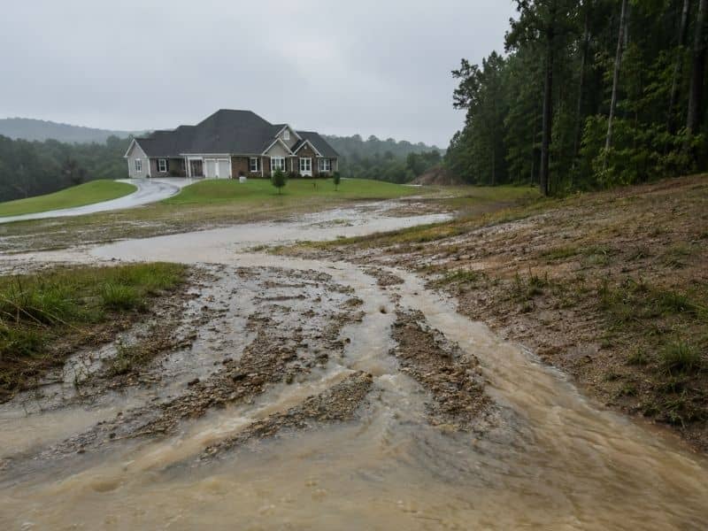
Common Drainage Problems Property Owners Face After Heavy Rain
Heavy rain can expose grading and drainage problems quickly. Property owners often discover standing water, erosion, muddy yards, and driveway washouts only after storms reveal how water naturally flows across the land.
Unfortunately, many drainage problems appear after construction begins.
A homeowner may finish grading the property only to notice standing water after the next storm. Others install a driveway before realizing runoff cuts through the gravel every time it rains.
Some property owners even add fill dirt to “fix” drainage problems. However, that can redirect water somewhere else instead.
These situations often lead to:
- Erosion
- Muddy yards
- Damaged landscaping
- Driveway washouts
- Water near foundations
- Expensive drainage repairs
Saturated soil can also shift more easily during heavy rain, especially on recently cleared land.
Meanwhile, a topographic survey helps identify many of these risks early.
How a Topographic Survey Helps Prevent Expensive Grading Mistakes
A topographic survey helps contractors and property owners plan grading more accurately. By understanding slopes and runoff patterns early, they can reduce drainage problems, improve water control, and avoid expensive repairs later.
Good grading starts with accurate information.
When contractors understand the shape of the land first, they can:
- improve runoff control,
- reduce erosion risk,
- avoid low areas,
- protect structures from water damage,
- and create better drainage planning.
As a result, projects often move smoother with fewer surprises later.
Instead of reacting to drainage problems after construction starts, property owners can plan ahead before major changes happen to the land.