
Land Surveying services are now available for the Ringgold, GA area. Please call Ringgold Land Surveying at (706) 222-3522 or send us an e-mail with your contact info to Su******@*******************ng.com. We are ready to discuss all your land surveying needs.
Land surveying – why do you need one? For any of the following reasons:
 So that you can see exactly what you are buying or selling.
- To determine if there are easement lines for utilities such as water, sewer, drainage ways, power lines, etc. on your property.
- To know if there are any encroachments like driveways, fences or buildings on the property.
- To know the exact property line measurements and the precise locations of all structures, fences, or driveways related to those property lines.
- land Surveying enables you to determine if you are in a floodplain.
- To be able to put up a fence on your property in the correct location.
- Land Surveying allows you to subdivide your property to divide it among family members.
- To make sure the building you’re constructing is on the lot, within the setback lines, and not encroaching on any easement lines.
The staff at Ringgold Land Surveying are eager to discuss your land surveying needs. We have experience in all types of land surveying. Some of these other survey types are more specialized. These are discussed below along with a brief explanation of each.
Money Saving Hint – if you need boundary lines marked it might be best to do that in the winter when the leaves are off. Ask us about splitting the job into two parts to accomplish these savings.
For more specific information about what type survey you need, please call Ringgold Land Surveying at (706) 222-3522 or fill out a contact form request.
Land Surveying Types:
Residential Lot or Mortgage Survey – A residential lot or mortgage survey is done to determine the location of your property lines and improvements (buildings, driveways, fences, etc.) Normally a survey drawing is included that may be used for a mortgage closing or for your records. A “lot” in this case is assumed to be part of a larger subdivision where multiple lots have been developed at one time and a plat has been recorded in the local courthouse. A lot is typically under an acre in size. The lot is then described, for example, as “Lot 21 of Peachy Subdivision Phase 2 as recorded in Plat Book 12, Page 32 in the Lee County Probate Office.” If the lot is described according to a deed description (metes and bounds) then we call that a boundary survey.
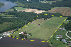 Boundary Survey – is normally on a much larger parcel, typically larger than one acre. This type involves locating the property corners as marked by an iron pipe, a rebar, or some other monument and preparing a survey drawing. Improvements on the parcel may or may not be located, depending on the proposed use of the survey. Boundary lines may or may not be marked, depending on the clients’ request. Easement lines, if any, will also be located.
Construction Staking – Surveying measurements that are made prior to, or while a site is under construction, to control the horizontal position and vertical position (elevation). For example, Surveyors typically place stakes at building corners for a new house site to insure that it is built in the proper location and does not encroach on any building line or easement. Construction staking is also done for work like curb and gutter, earthwork, sanitary manholes, streets, etc.
Site Plan – A site plan is prepared, normally, in order to obtain approval to construct some type structure on a lot, like a house. This may involve field work, depending on the circumstances. The majority of site plans are completed in the office. After approval of the site plan, then some construction staking might take place. (See above)
Topographic Survey – A survey that locates natural and man-made features such as buildings, fences, improvements, easements, utilities, trees, streams. This type also normally shows the “contours” of the land. Shots are taking at “ridges” and “valleys” on the site and a map is produced. A topo survey is normally used to plan and design some type of building project on the parcel.
Subdivision Survey – This type is done in order to divide a parcel into smaller parcels. This might be as few as two lots or hundreds or lots. A subdivision “plat” (drawing) is completed which is then approved by the county and/or city and then recorded in the local courthouse.
Elevation Survey – Performed to determine the elevation of a structure (house) and it’s relation to the floodplain. (See “flood” for more information.)
ALTA/ACSM Survey – This type can be similar to the Residential Lot or Boundary Survey above but it is done to a different standard, the ALTA/ACSM standard. ALTA is the American Land Title Association and ACSM is the American Congress on Surveying and Mapping. These two organizations joined together in developing these standards. They are updated regularly. This is normally referred to as an ALTA survey. An ALTA survey is very comprehensive (read costly) and is most often performed on commercial property or when a lender is out of state. This is a widely accepted national standard for land surveying.
Call Ringgold Land Surveying at (706) 222-3522 or send us an e-mail with your name, address and phone number to Su******@*******************ng.com to discuss your land surveying needs or fill out a contact form.